The geology and mineral resources of the North West, Central and Eastern Divisions Between long. 119° and 122 °E, and lat. 22° and 28 °S. (Bulletin of the Geological Survey of Western Australia No 83)
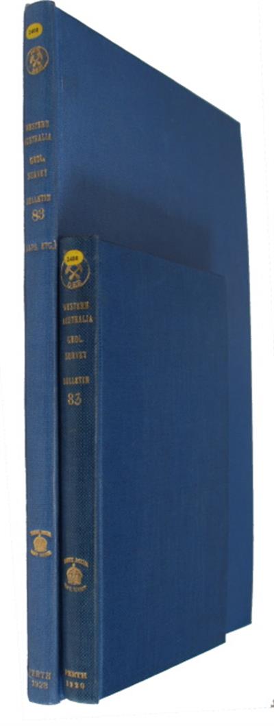
- Series : Geological Survey Western Australia Bulletin
Volume: 83 - Published In : Perth
- Illustrations : 15 folding col plates, 55 figs, 1 folding frontispiece map
Description:
With a chapter on Petrology by R.A. Farquharson. Henry William Beamish Talbot (1874 – 1957) ‘will always be remembered as a pioneering geologist and explorer during the heroic early days of the Geological Survey of Western Australia, and as a pioneer economic geologist in the State’s mining and petroleum industries’ (John Blockley, Geological Society of Australia). The introduction states this bulletin ‘represents the results of three years’ work’. The author ‘with three men as camp assistants and camel men, was engaged upon it during the field seasons of 1912-13 and 1914’….’as a result most of the physical features over an area of approximately 70,000 square miles have been mapped’. The report is accompanied by a separate atlas of four miles per inch series of geological maps.
Condition
2 vols, buckram. From an Institutional library: stamps/ withdrawn stamps to titles pages and verso of maps. Good. Frontispiece bound at rear.
Other titles from the series : Geological Survey Western Australia Bulletin
Click to view all titles in this series...
![The Field Geology and broader mining features of the Leonora-Duketon district, including parts of the North Coolgardie, Mt. Margaret, and East Murchison Goldfields and a Report on the Anaconda Copper Mine and neighbourhood, Mt. Margaret Goldfield [and] The Geology and Mineral Resources of the Yalgoo Goldfield. Part II. The Mining Centres of Rothesay and Goodingnow (Payne’s Find) [and] The Geology of a portion of the East Coolgardie and North-East Coolgardie Goldfields, including the Mining centr](/ProductImage.aspx?File=40267.jpg&Size=60)
The Field Geology and broader mining features of the Leonora-Duketon district,
Clarke, E. de C.
Price £195.00

Some Economic Aspects of the Principal Tantalum-Bearing Deposits of the Pilbara
Ellis, H.A.
Price £50.00
Part I, Geology of Portion of the Mt. Margaret Goldfield. Part II, Garnetised
Hobson, R.A.; Miles, K.R
Price £195.00
Miscellaneous Reports for 1954 (Western Australia Geological Survey. Bulletin
Geological Survey Western Australia
Price £125.00
The Geology of the Phillips River Goldfield, W.A. (Western Australia Geological
Sofoulis, J.
Price £150.00
You may also like...

The Princeton Encyclopedia of Dinosaurs: Ornithischians
Jones, B.; Viola, E. (Illus.)
Price £31.50
(Save £10.50)

The Princeton Encyclopedia of Dinosaurs: Theropods
Jones, B.; Viola, E. (Illus.)
Price £33.75
(Save £11.25)

The Princeton Encyclopedia of Dinosaurs: Sauropods
Jones, B.; Viola, E. (Illus.)
Price £28.50
(Save £9.50)

The Princeton Field Guide to Mesozoic Plants
Arens, N.C.; Csotonyl, J. (Illus.); Mazzei, S. (Illus.); Hsu, S. (Illus.)
Price £22.50
(Save £7.50)

